
AN INTEGRATED BIM–GIS METHODOLOGY FOR AS-BUILT INFRASTRUCTURE MODELING AND ANALYSIS: A CASE STUDY
DOI:
https://doi.org/10.11113/jurnalteknologi.v88.25584Keywords:
Building Information Modeling (BIM); Geographic Information System (GIS); IFC; CityGML; Infrastructure ManagementAbstract
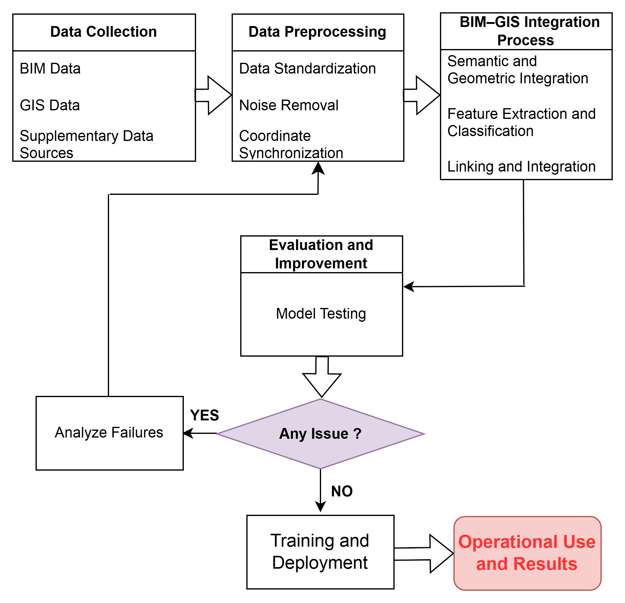
Integrating Building Information Modeling (BIM) and Geographic Information Systems (GIS) remain challenging due to differences in data schemas, coordinate systems and semantic representation. This paper proposes and validates a VN-tailored BIM–GIS workflow for as-built infrastructure modeling that (i) standardizes data exchange using IFC and CityGML, (ii) harmonizes spatial data to the VN-2000 coordinate system, and (iii) automates semantic mapping via FME middleware. The workflow fuses multi-sensor acquisitions (UAV–LiDAR, terrestrial laser scanning — TLS, handheld SLAM, GNSS-RTK and GPR) to produce a high-fidelity digital twin of the University of Transport and Communications (UTC) campus (Hanoi). Geometric validation comprised two stages: point-cloud vs CAD (64.3% of points within ±0.10 m; 86.5% within ±0.30 m) and BIM vs point-cloud (91.4% of points within ±0.05 m), confirming centimeter-level alignment for most elements. The integrated model, deployed in ArcGIS Pro, enables asset tracking, space-use queries and risk analyses (e.g., flood susceptibility), demonstrating operational utility for facility and infrastructure management. The study contributes a practical, policy-relevant pipeline that preserves semantic and geometric fidelity for national-scale applications and outlines directions for automation, semantic interoperability and IoT-enabled digital twins.
References
[1] Liu, X., X. Wang, G. Wright, J. C. Cheng, X. Li, and R. Liu. 2017. A State-of-the-Art Review on the Integration of Building Information Modeling (BIM) and Geographic Information System (GIS). ISPRS International Journal of Geo-Information. 6(2): 53.
[2] Deng, T., and Q. Zhang. 2022. Application of GIS in Urban Planning Information System. In 2022 International Conference on Data Analytics, Computing and Artificial Intelligence (ICDACAI). 127–31. IEEE.
[3] Abbas, A., G. Salloom, F. Ruddock, R. Alkhaddar, S. Hammoudi, R. Andoh, and I. Carnacina. 2019. Modelling Data of an Urban Drainage Design Using a Geographic Information System (GIS) Database. Journal of Hydrology. 574: 450–66.
[4] Tran, H. V. V., and T. A. Nguyen. 2024. A Review of Challenges and Opportunities in BIM Adoption for Construction Project Management. Engineering Journal. 28(8): 79–98.
[5] Noardo, F., et al. 2020. Tools for BIM-GIS Integration (IFC Georeferencing and Conversions): Results from the GeoBIM Benchmark 2019. ISPRS International Journal of Geo-Information. 9(9): 502.
[6] Lam, P. D., B. H. Gu, H. K. Lam, S. Y. Ok, and S. H. Lee. 2024. Digital Twin Smart City: Integrating IFC and CityGML with Semantic Graph for Advanced 3D City Model Visualization. Sensors. 24(12): 3761.
[7] Sani, M. J., I. A. Musliman, and A. Abdul Rahman. 2022. IFC to CityGML Conversion Algorithm Based on Geometry and Semantic Mapping. The International Archives of the Photogrammetry, Remote Sensing and Spatial Information Sciences. 46: 287–93.
[8] Biljecki, F., et al. 2021. Extending CityGML for IFC-Sourced 3D City Models. Automation in Construction. 121: 103440.
[9] Błaszczak-Bąk, W., A. Masiero, P. Bąk, and K. Kuderko. 2024. Integrating Data from Terrestrial Laser Scanning and Unmanned Aerial Vehicle with LiDAR for BIM Developing. The International Archives of the Photogrammetry, Remote Sensing and Spatial Information Sciences. 48: 25–30.
[10] Rashdi, R., J. Martínez-Sánchez, P. Arias, and Z. Qiu. 2022. Scanning Technologies to Building Information Modelling: A Review. Infrastructures. 7(4): 49.
[11] Yuan, Z., and Q. Shen. 2010. Using IFC Standard to Integrate BIM Models and GIS. Paper presented at the International Conference on Construction and Real Estate.
[12] Ren, G., A. Khudhair, H. Li, X. Wen, and X. Zhu. 2025. Leveraging BIM Data Schema for Data Interoperability in Ports and Waterways: A Semantic Alignment Framework for OpenBIM Workflows. Buildings. 15(12): 2007.
[13] Wang, M., P. K. Y. Wong, and J. C. Cheng. 2025. A BIM-GIS Framework Integrated with CCTV Analytics for Urban Walkability Assessment. Sensors. 25(12): 3637.
[14] Zhang, S., D. Hou, C. Wang, F. Pan, and L. Yan. 2020. Integrating and Managing BIM in 3D Web-Based GIS for Hydraulic and Hydropower Engineering Projects. Automation in Construction. 112: 103114.
[15] Hijazi, I. H., M. Ehlers, and S. Zlatanova. 2012. NIBU: A New Approach to Representing and Analysing Interior Utility Networks within 3D Geo-Information Systems. International Journal of Digital Earth. 5(1): 22–42.
[16] Ma, R., C. Yi, L. Zhang, and J. Yan. 2020. Design of and Research on Underground Pipeline System in Campus Based on 3DGIS. In E3S Web of Conferences 165: 03004. EDP Sciences.
[17] Bhatti, I. A., A. H. Abdullah, S. Nagapan, N. B. Bhatti, S. Sohu, and A. A. Jhatial. 2018. Implementation of Building Information Modeling (BIM) in Pakistan Construction Industry. Engineering, Technology & Applied Science Research. 8(4): 3199–3202.
[18] Yasir, M., Z. Khurshid, U. A. Raja, H. Khurshid, A. M. Khan, and K. Lawani. 2024. The Use of Building Information Modelling (BIM) in the Management of Construction Safety: The Development towards Automation Hazard Identification and Assessment. International Journal of Science and Research Archive. 11(2): 830–52.
[19] Moxham, C. 2005. The Lean Design Guidebook: Everything Your Product Development Team Needs to Slash Manufacturing Cost. International Journal of Operations & Production Management. 25(9): 938.
[20] Tran, K. P., T. D. Nguyen, T. T. Luc, P. L. M. Tri, and P. T. Tran. 2025. Integrating Port Planning Information into a Web-Based Geographic Information System Platform. In Ports 2025, 380–92.
[21] Ngoc, N. M., N. A. Dung, T. D. Hung, and T. N. Thang. 2024. Challenges of BIM Technology and Lean Theory in the Construction Industry in Vietnam. Engineering, Technology & Applied Science Research. 14(5): 17548–54.
[22] Thakuriah, P. V., K. Sila-Nowicka, J. Hong, C. Boididou, M. Osborne, C. Lido, and A. McHugh. 2020. Integrated Multimedia City Data (iMCD): A Composite Survey and Sensing Approach to Understanding Urban Living and Mobility. Computers, Environment and Urban Systems. 80: 101427.
[23] Kuru, K. 2021. Planning the Future of Smart Cities with Swarms of Fully Autonomous Unmanned Aerial Vehicles Using a Novel Framework. IEEE Access. 9: 6571–95.
[24] Pratiwi, A. A. R., C. Afriade, M. Syukri, H. H. Ismail, D. Y. Sari, and T. Sugiri. 2024. LiDAR: Digitalization of Urban Infrastructure Monitoring. In 2024 18th International Conference on Telecommunication Systems, Services, and Applications (TSSA). 1–6. IEEE.
[25] Isikdag, U. 2006. Towards the Implementation of Building Information Models in Geospatial Context. University of Salford.
[26] Dong, S., X. Wang, F. Zhao, J. Zhang, C. Li, and J. Wang. 2024. Research on Fusion and Integration Method of BIM and GIS Data. In Proceedings of the 2024 3rd International Conference on Artificial Intelligence, Internet and Digital Economy (ICAID 2024), 99–108. Atlantis Press.
[27] Wang, M., P. K. Y. Wong, and J. C. Cheng. 2025. A BIM-GIS Framework Integrated with CCTV Analytics for Urban Walkability Assessment. Sensors. 25(12): 3637.
[28] Liu, A. H., C. Ellul, and M. Swiderska. 2021. Decision Making in the Fourth Dimension—Exploring Use Cases and Technical Options for the Integration of 4D BIM and GIS during Construction. ISPRS International Journal of Geo-Information. 10(4): 203.
[29] Susetyo, D. B., and A. P. Perdana. 2016. Automation of Indonesian Topographic Data Quality Control Using Data Reviewer. In International Conference on Technology, Innovation, and Society (ICTIS). 2016.
[30] Hieu, P. D., and T. B. Giang. 2019. Modernizing Geodetic Infrastructure for the Fourth Industrial Revolution in Vietnam. Paper presented at FIG Working Week, April.
[31] Gröger, G., and L. Plümer. 2012. CityGML—Interoperable Semantic 3D City Models. ISPRS Journal of Photogrammetry and Remote Sensing. 71: 12–33.
[32] Li, X., P. Wu, G. Q. Shen, X. Wang, and Y. Teng. 2017. Mapping the Knowledge Domains of Building Information Modeling (BIM): A Bibliometric Approach. Automation in Construction. 84: 195–206.
[33] Nepal, M. P., S. Staub-French, R. Pottinger, and J. Zhang. 2013. Ontology-Based Feature Modeling for Construction Information Extraction from a Building Information Model. Journal of Computing in Civil Engineering. 27(5): 555–69.
[34] Kang, T. W., and C. H. Hong. 2015. A Study on Software Architecture for Effective BIM/GIS-Based Facility Management Data Integration. Automation in Construction. 54: 25–38.
[35] Ji, Y., Y. Wang, Y. Wei, J. Wang, and W. Yan. 2024. An Ontology-Based Rule Mapping Approach for Integrating IFC and CityGML. Transactions in GIS. 28(3): 675–96.
[36] Prime Minister of Vietnam. 2023. Decision No. 258/QĐ-TTg: Approving the Roadmap for the Application of Building Information Modeling (BIM) in the Construction Sector.
[37] Ministry of Construction, Vietnam. 2025. Decision No. 554/QĐ-BXD: Digital Transformation Program for the Construction Sector.
Downloads
Published
Issue
Section
License
Copyright of articles that appear in Jurnal Teknologi belongs exclusively to Penerbit Universiti Teknologi Malaysia (Penerbit UTM Press). This copyright covers the rights to reproduce the article, including reprints, electronic reproductions, or any other reproductions of similar nature.